
A DEVELOPMENT of more than 2,000 new homes could be built close to the villages of Henfield and Westerleigh.
The development of 2,050 homes and 18 hectares of employment land has been named North Lyde Ecotech Village, and is included in the final version of South Gloucestershire Council’s draft Local Plan.
The homes are south of Henfield and the Kendleshire golf club, bounded by the M4, Westerleigh Road and the railway line serving the Westerleigh fuel depot at the eastern edge of the site.
Much of it is currently farmland but it also includes the Windmill Leisure Golf and Activity Centre, Windmill Fishery, South Gloucestershire Showground and Tulip abattoir.
Details of the places where new housing developments could be built across South Gloucestershire are set out in detail in the final draft of the council’s Local Plan.
The plan also includes proposals to allow 2,400 homes near the M4/M5 interchange between Almondsbury and Winterbourne, and 385 homes on smaller sites around existing Frome Valley villages.
North Lyde Ecotech Village

ABOUT 2,050 homes and 18 hectares of employment land, extending the Bristol & Bath Science Park, have been proposed south of Henfield and the Kendleshire golf club.
The area to be developed is bounded by the M4, Westerleigh Road and the railway line serving the Westerleigh fuel depot at the eastern edge of the site.
Much of it is currently farmland but it also includes the Windmill Leisure Golf and Activity Centre, Windmill Fishery, South Gloucestershire Showground and Tulip abattoir.
A total of 2,050 homes have been proposed for the site; between 1,050 and 1,350 would be built before 2041 and the rest afterwards.
The development would include shops and cafes, a community centre, nursery, primary school, library, GP surgery and a central play park.
Buildings could be up to six storeys tall.
The development has been named North Lyde as it is on the immediately opposite side of the M4 to the Lyde Green estate, which is still being built.
Another 453 homes at Lyde Green Farm and Lyde Green Road are included in the plan, next to existing housing development sites.
New Woodlands
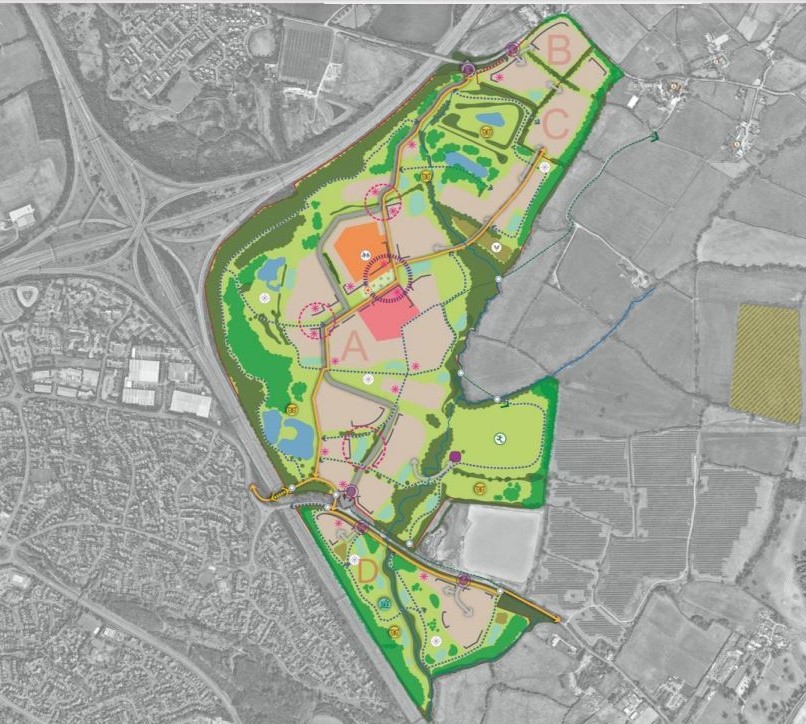
A TOTAL of 2,400 homes would be built on land east of the Almondsbury M4/M5 interchange north west of Winterbourne, effectively moving the edge of the existing Bristol urban sprawl north beyond the motorway from Bradley Stoke.
The new village will be across four sites, including Woodlands Golf Course, which will have 1,900 new homes, at least 250 of which will be “age-friendly” for older people. Some 30% will be classed as affordable, for social rent or non-market sales.
There will also be a shop, cafe/restaurant, indoor leisure, community meeting spaces, nursery, doctors’ surgery, primary schools, offices and small affordable workspaces.
The nearby bridge across the M4 will be widened for pedestrians, cyclists and buses, while an outdoor sports complex will be built east of Hortham Brook, next to the West Country Water Park.
About 330 homes will be built at two sites north of the new village and 170 to the south, off Trench Lane.
Frome Valley village sites
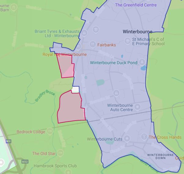
FRAMPTON Cotterell, Winterbourne, Coalpit Heath and Iron Acton have largely avoided major development sites under the proposals.
However some places in each village have been included as potential sites for new homes.
The biggest are in Winterbourne, where an area of land west of Winterbourne Hill and south of homes on Beacon Lane is earmarked for 100 homes by 2041 and a second field north of the railway line between Mill Road and Bristol Road is earmarked for 70 homes.
A field off Park Lane in Coalpit Heath, just north of the railway line and south of a recent housing development, has been allocated as a site for 95 new homes.
The former Watermore school site in Woodend Road, Frampton Cotterell, is allocated for 20 homes, while 60 homes could be built between Bristol Road and Perrinpit Road, opposite the BP garage.
Land between York Gardens and the Fromeside Gymnastics Club in Winterbourne is suggested as a site for 20 homes.
In Iron Acton, land at Holly Hill Farm has been suggested as suitable for 20 homes.
The plan also includes new traveller sites at Beech House, Iron Acton, Church Lane, Rangeworthy,
Rectory Lane, in Cromhall, Swan Lane and Northwood Park in Winterbourne, along with extra pitches at Henfield, Nibley, Frampton Park in Frampton Cotterell and Latteridge Road, Iron Acton.
Consultation opens
The final draft of the Local Plan is now open for public comments.
Full details will be found on the plan website, localplan.commonplace.is
Anyone who is not online can call 01454 868009 for help.
Protests at plan meetings
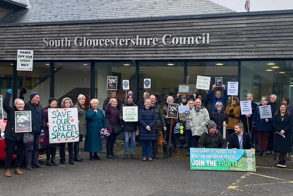
Protesters voiced their anger at the proposed “decimation of the Green Belt” as councillors approved the 15-year blueprint for the future of South Gloucestershire.
The council’s Liberal Democrat and Labour councillors voted in favour at council meeting on February 12.
The joint administration insisted that although some decisions had been painful, it would provide new homes in places that could be supported by infrastructure such as schools, GP surgeries, employment, roads and public transport.
They said that if the plan was not published by March 12, new government housing targets would apply, and mean having to add an extra 5,000 homes.
Campaign group Save Our Green Spaces South Gloucestershire (SOGS-SG) has criticised the authority for allocating huge swathes of the greenbelt for development.
Opposition Conservatives voted against the plan and demanded changes.
Includes reporting by Adam Postans, Local Democracy Reporting Service
Top picture: SOGS-SG protesters outside a South Gloucestershire Council cabinet meeting in February